 and
and 

RTK Applications: Maritime & Inland Waterways
Marine robotic vehicles, like ROVs, AUVs, and USVs, are transforming subsea exploration and monitoring. They offer a cost-effective, safe, and environmentally friendly way to inspect waterways, map the seafloor, and study marine ecosystems with centimeter level accuracy of GPS position. Surprised by such accuracy? Find out in our 5-min video how the RTK technology works.
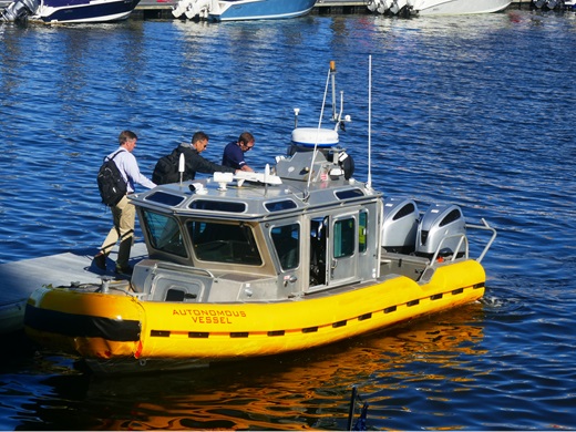
Autonomous Ships
As the automotive industry ventures into autonomous cars, maritime engineers are developing skipperless ships for the open seas. These autonomous vessels, powered by RTK and AI, promise to revolutionize the shipping industry by improving safety and efficiency. They are designed to navigate autonomously, avoiding hazards and optimizing routes without human intervention. The integration of RTK technology allows these ships to perform precise maneuvers, even in challenging conditions. This innovation is particularly beneficial for tasks deemed too risky for human crews, such as operating in extreme weather or near hazardous materials.
Looking for an affordable GNSS Compass for your vessel? Tired of high prices? Explore How to build a low cost NMEA2000 GNSS Compass with optional RTK functionality.
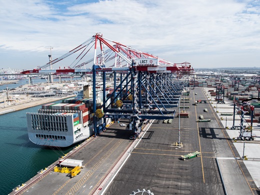
Automated port operations
Automating port machinery, such as reach stackers and straddle carriers, is crucial for the efficiency of smart terminals. By using multi-frequency GNSS receivers, ports ensure reliable positioning even when direct sky visibility is obstructed. GNSS/INS systems provide uninterrupted positioning capabilities, crucial during brief GNSS signal losses, for instance, when equipment is under a crane. This technology also reduces reliance on magnetic sensors, which perform poorly near metal structures, enhancing operational safety and reliability.
Check out ArduSimple GNSS/RTK receivers with INS feature simpleRTK2B SBC – Development Kit and simpleRTK2B Fusion.
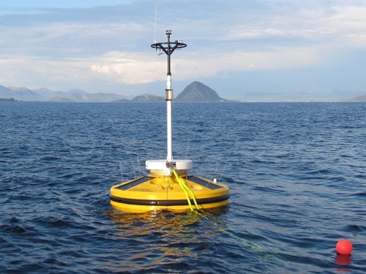
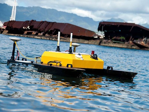
Buoy
GNSS RTK buoys play a pivotal role in precise, real-time water surface monitoring and surveying. Capable of employing both real-time kinematic and post-processing techniques, these buoys are invaluable for data collection in remote ocean areas, far from land-based GNSS stations. In coastal zones, where buoys face higher risks of damage, utilizing cost-effective RTK receivers and RTK antennas becomes crucial. This approach ensures continuous, high-accuracy data collection essential for various maritime applications, from navigation safety to environmental monitoring.
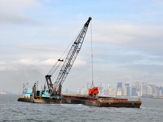
Dredging
Dredging and underwater construction benefit greatly from RTK network technology. By providing exact underwater positioning, RTK systems ensure the precise placement of dredging equipment. This accuracy is crucial for environmental conservation and efficient project execution. Integrating RTK GPS into dredging operations streamlines the process, allowing for real-time adjustments and improved.
Fish finder
The use of unmanned vehicles powered by RTK for fish stock detection represents a leap forward in sustainable fishing practices. Equipped with advanced sensors, these vehicles can locate krill and fish, aiding in conservation and resource management. By providing accurate data to fishing crews, they help minimize unnecessary fishing activity and reduce fuel consumption. This approach not only conserves marine life but also supports the fishing industry’s economic sustainability and reduces time searching with the fishing boat. It helps to avoid unnecessary emissions from large fishing boats.
Hydrographic Survey
Hydrographic surveys play a pivotal role in mapping underwater terrains, and the integration of RTK GPS technology has revolutionized these surveys by providing centimeter-level accuracy in positioning. This precision is critical for detailed seafloor mapping and effective water level corrections, thus eliminating the reliance on traditional tide gauges.
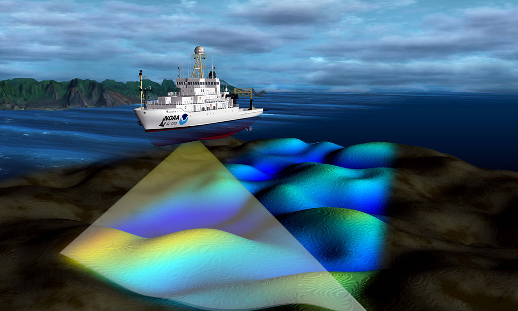
The development of specialized vessels designed to excel in hydrographic survey conditions complements the effectiveness of RTK GPS receivers. These vessels are equipped with autonomous features like position hold and automated transects, meeting the hydrographer’s needs for efficiency and accuracy. Their design focuses on overcoming common hydrographic challenges, significantly improving the quality and speed of data collection. This synergy between advanced RTK technology and specially designed survey vessels ensures unparalleled precision and efficiency in hydrographic surveys, enabling a deeper understanding of aquatic environments. Check out more Survey and Mapping use cases.
Hull cleaning robot
Biofouling on ship hulls significantly impacts fuel efficiency and environmental pollution. Hull cleaning robots powered by RTK offer a safe and efficient solution by attaching to the ship’s hull and removing marine growth. These robots use a combination of rotating brushes and water jets, controlled through negative pressure vortices, to clean the hull. This preventive maintenance leads to significant fuel savings and reduce harmful emissions. By automating hull cleaning, the maritime industry can ensure vessel performance while minimizing environmental impact.
Do you want to know if RTK works underwater? Check out the post tittled GPS can’t work underwater: myth or reality?
Marine data collection
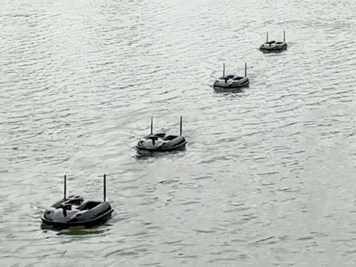
Unmanned Surface Vessels (USVs) are at the forefront of marine data collection. These versatile platforms are equipped to perform a variety of tasks, from hydrography and bathymetry to water quality inspections. Operating autonomously or via remote control, USVs can safely access difficult or dangerous areas with accuracy of position up to 1 centimeter. They can be outfitted with a range of instruments, including echosounders, sonars, and LIDAR, to gather comprehensive data. This capability is invaluable for environmental monitoring, resource management, and scientific research. Learn more how RTK can be used for coastal terrain monitoring.
Ship mooring
RTK technology is revolutionizing the management of moored ships. High-precision systems measure ships’ movements with remarkable accuracy, allowing for detailed analysis of how marine conditions affect them. This data is crucial for defining safe operating conditions and preparing for adverse weather. By understanding the ship’s behavior in response to waves and currents, operators can enhance safety and operational efficiency. The use of RTK GPS systems in monitoring moored ships exemplifies the integration of technology in maritime logistics and safety protocols.
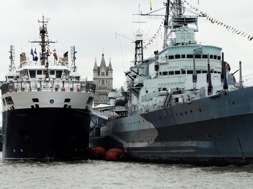
Knowing a ship’s heading is crucial for ship mooring because it ensures safe and precise docking, minimizing the risk of collision or damage. Learn more about what it is heading and how GPS can help you measure the real heading of your vessel.
Surveillance boat
Ensuring the security of ports and harbors presents a challenging and costly endeavor. Monitoring extensive maritime areas for potential threats requires advanced technology. GNSS RTK solutions, combined with sensor fusion technology, empower security teams to establish temporary security zones around critical assets such as ships and containers. This setup enables the swift detection and reporting of unauthorized movements or changes, bolstering port security.
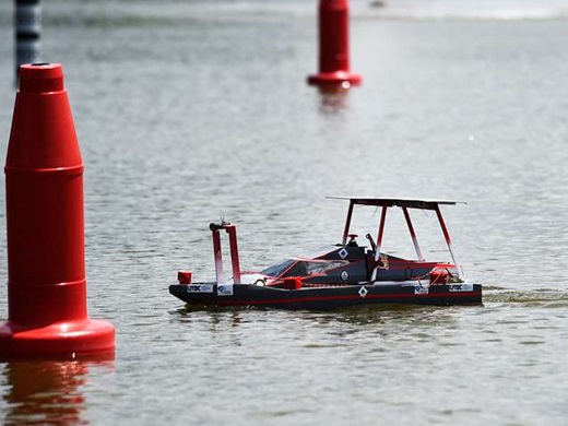
Check out low cost simpleRTK2B Fusion receiver with dead reckoning/sensor fusion feature.
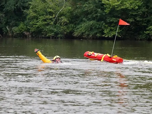
Water Rescue Robot
In emergency situations, water rescue robots provide a quick and effective response. These robots are designed for rapid deployment in seas, lakes, rivers, and reservoirs to assist in rescue operations. Equipped with advanced navigation and detection technology, they can quickly locate individuals in distress. Operating on the water’s surface, these robots offer a safer alternative to human rescuers, especially in dangerous or inaccessible areas. With the aid of an RTK system, water rescue efforts can achieve centimeter-level accuracy, enhancing both safety and efficiency.
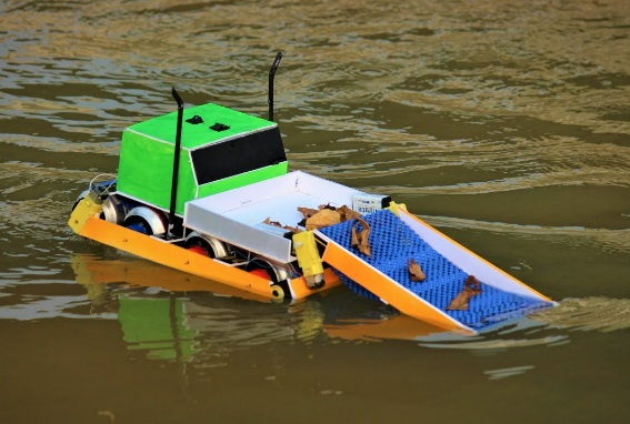
Water Surface Cleaning
Water surface cleaning vessel is highly effective remotely piloted or autonomous boat for water surface cleaning in lakes, harbours, marinas, reservoirs and industrial facilities. Equipped with a high-capacity cleaning system, the uncrewed surface vessel is capable of removing floating solid waste as well as hydrocarbon spills. Aquatic robots have been deployed around the world to undertake marine and ocean restoration missions: waste removal, microplastics filtering, and biodiversity analysis. Are you curious if GPS cannot work underwater? Check out the post if it is myth or really.
For engineers eager to master maritime navigation and understand the nuances of heading, course, track, and yaw, our tutorial on How GPS can help you measure the Heading of your vessel offers comprehensive insights. Dive in to elevate your expertise.

