 and
and 

RTK GPS News
Overview As part of our mission to support accurate positioning solutions in challenging environments, ArduSimple was proud to contribute GNSS technology to an outdoor ...

Today we are launching a new radio module compatible with the unlicensed 450 MHz spectrum. The new Radio module 450MHz allows you to connect ...
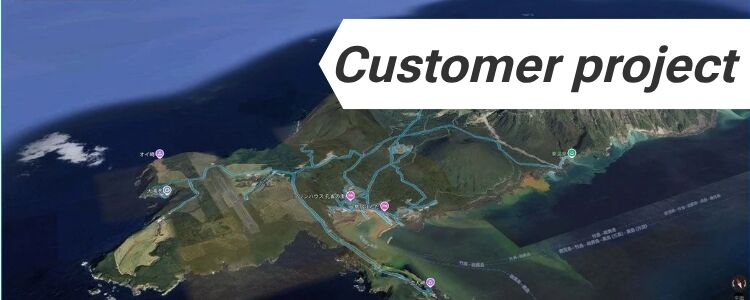
Overview This customer project comes from Aryonix, founded by Alexandre Cavaleri. Aryonix develops a real-time rendering engine capable of creating cinematic, photorealistic and immersive ...
Table of contents A sailing yacht equipped with a Raymarine EV-100 autopilot has been successfully upgraded with a high-precision GNSS system based on an ...
RTK Portable 2: Compact High-Precision GNSS RTK Receiver RTK Portable 2 makes centimeter-level GNSS positioning simple and portable — whether you’re working in agriculture, ...
We recently moved to a new logistics office and warehouse and we thought it would be a good idea to review a bit of ...
Table of contents Description Before starting a road or any other heavy construction project the site ground has to be settled in the first ...
The ArduSimple team will be in London this June for GEO Business 2026. If you’re attending, we’d love to see you at Booth G107 ...
We are excited to introduce the new u‑blox ZED‑X20D evaluation board, designed for centimeter-level positioning and high-precision heading. With two GNSS antennas, the board ...
Can a low-cost GNSS antenna perform like a geodetic one? A research paper in GPS Solutions says: often yes — if you choose carefully. ...
https://www.youtube.com/watch?v=lw98kjCjMbM ArduSimple has introduced the RTK Smart Antenna, a new type of high-precision GNSS receiver designed to be configurable, modular, and repairable. It allows ...
Meet the new RTK Handheld 2 Mapping Kit. We listened to your feedback and upgraded the kit with the features you asked for. Looking ...
Looking for a IP67 weatherproof plastic enclosure for your project? We spent some time looking for something off-the-shelf like this, to be able to ...
Table of contents RTK Black Week is here — and you can save up to 50%.If you’ve been planning an upgrade or need an ...
