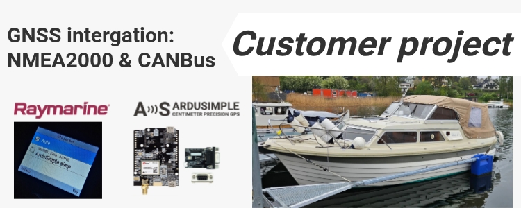
Update (26/06/2026): We have plenty of stock of all our products, find us also in and    How to get a quotation

CustomerProjects

High-precision GNSS integration for Raymarine autopilot via NMEA 2000

High-precision GNSS integration for Raymarine autopilot via NMEA 2000

Table of contents A sailing yacht equipped with a Raymarine EV-100 autopilot has been successfully upgraded with a high-precision GNSS system based on an ArduSimple receiver and CAN bus (NMEA 2000) interface. The system is currently installed and operating on board. It provides GNSS positioning data directly to the vessel’s NMEA 2000 network, where it […]

High-precision GNSS integration for Raymarine autopilot via NMEA 2000 Read More »

customer project how to use RTK for soil and water cycle survey

Soil and water cycle survey using RTK and QGIS

Survey objective: precise mapping of drainage and soil conditions Across several Finnish municipalities, the Maa-Akatemia (Soil/Land Academy) team studied how water moves through farmland and how soil structure influences it. Their goal was to give farmers and local authorities clear maps showing the condition of drainage systems and soil health — two key parts of

Soil and water cycle survey using RTK and QGIS Read More »

How GNSS RTK help forestry machines drive stable on rough terrain

How GNSS RTK helps forestry machines drive stable on rough terrain

Researchers at Umeå University tested how RTK GNSS can support artificial intelligence (AI) control systems in large forestry machines (full article is available here). The goal was to check if a vehicle control system trained only in computer simulation could work directly on a real 31-ton forestry forwarder without further tuning — a process called

How GNSS RTK helps forestry machines drive stable on rough terrain Read More »

Portable 3D tracking system to test agricultural robots in the field

Portable 3D tracking system to test agricultural robots in the field

The challenge: how to test autonomous robots reliably Testing autonomous agricultural robots is not easy. Farmers and researchers need to know if these machines can work safely and stay inside defined areas (geofences). Existing test setups were limited: they were fixed in place, could only track one object, and did not work well in real

Portable 3D tracking system to test agricultural robots in the field Read More »

affordable solution for kinematic mapping using spherical camera and GNSS/RTK

Low-cost alternative to mobile scanners: mapping with 360° camera and GNSS

Why cheaper mobile 3D mapping tools are needed Professional mobile scanning systems are accurate, but often cost over €50,000 like Faro Orbis mobile scanner. This makes them too expensive for small teams or schools. There is a need for affordable alternative systems that cost around €1,000, are portable, easy to use, accurate, and work with

Low-cost alternative to mobile scanners: mapping with 360° camera and GNSS Read More »

Got any questions or requests?
Contact us! We'll answer <24 hours!

Icon
Contact ArduSimple
Close
ArduSimple – high precision RTK survey equipment and solutions made simple

Want to learn more about GPS and RTK?

If you are busy right now, our engineers can send you 3 short e-mails, explaining all you need to know to start your project.