Update (03/10/2025): We have plenty of stock of all our products, find us also in and    Shop now

February 3, 2021

geoid for orthometric height measurements cover

How to use custom geoid for orthometric height measurements in Android with Mapit GIS or Mapit Spatial

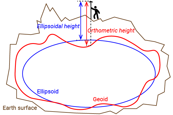
For some applications you may need to use a high quality orthometric height (height above mean sea level) measurement in real time. In orthometric height, planet earth shape at sea level is modelled with high detail (geoid).In this tutorial we will explain step by step how to use a custom geoid for high quality orthometric height measurements […]

How to use custom geoid for orthometric height measurements in Android with Mapit GIS or Mapit Spatial Read More »

orthometric ellipsoidal geoid height

Ellipsoidal, orthometric and geoid height 101

Many customers get confused with the different heights (altitude) reported by their GNSS receiver.In this post we will show the concept of each one with plain words (we apologize to all surveyors and scientists that read this post). Ellipsoidal height:Planet earth shape is simplified as a rugby ball (ellipsoid).Ellipsoidal height is the vertical distance between

Ellipsoidal, orthometric and geoid height 101 Read More »

Got any questions or requests?
Contact us! We'll answer <24 hours!

Icon
Contact ArduSimple
Close

Want to learn more about GPS/RTK?

1. Our engineering team will contact you to solve any questions
2. We will keep you updated about promotions and new product releases
3.You will only hear from us when we have important news, we won’t spam your email