Update (28/08/2026): We have plenty of stock of all our products, find us also in and    How to get a quotation

How to validate RTK surveying accuracy in Japan

manual How to validate RTK surveying accuracy in Japan

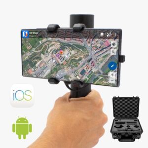
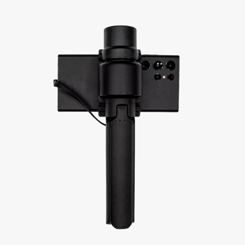
This tutorial demonstrates how to achieve centimeter-level RTK GNSS positioning in Japan by configuring a low-cost kit—the RTK Handheld 2 Mapping Kit —with NTT DOCOMO’s High-Precision GNSS Location Information Service and validating its accuracy against official geodetic control points.

In Japan, commercial providers such as NTT DOCOMO and SoftBank offer paid NTRIP correction services. Free public NTRIP casters, such as rtk2go.com and GeoRTK, are also available. However, many free NTRIP casters are operated by individuals or private organizations. They may become unavailable due to maintenance or communication issues, or they may not provide sufficient correction accuracy depending on the region. Therefore, for commercial use or tasks requiring stable RTK positioning, using a paid NTRIP service is recommended.

This tutorial explains how to use the low cost GPS RTK it for high accuracy positioning using the NTT DOCOMO High-Precision GNSS Location Information Service, which offers reliable nationwide coverage in Japan. Additionally, it covers how to verify RTK positioning accuracy by comparing surveyed coordinates with published control point data using official public survey control points from the Geospatial Information Authority of Japan (GSI).

Required hardware:

Required software:

  • SW Maps (for Android or iOS)

RTK in Japan: Validate RTK accuracy using a low-cost RTK kit and correction service on geodetic point

Register to high-precision service (NTT DOCOMO)

This section explains how to set up and start using NTT DOCOMO’s High-Precision GNSS Location Information Service (NTRIP method), covering the process from registration to receiver configuration.

Service Application
ID & Password Issued
Configure NTRIP on the Receiver
RTK FIX
Figure 1: Overall Service Workflow
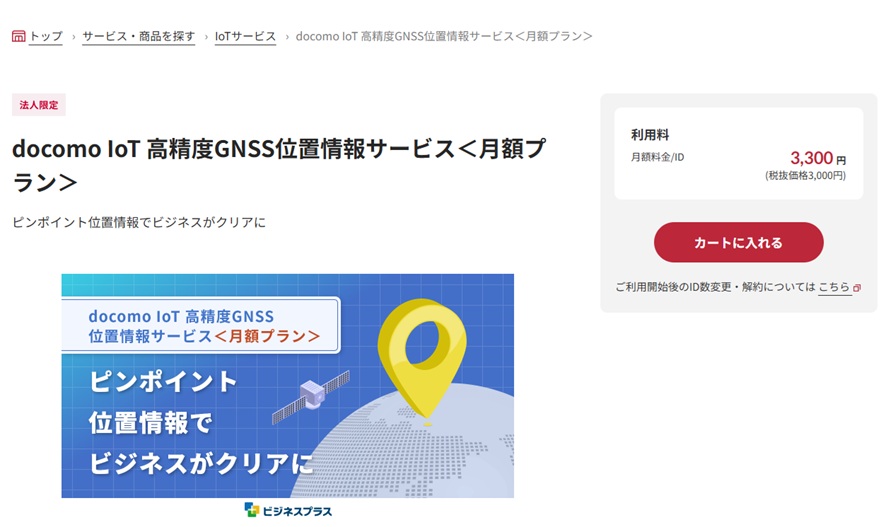
  1. Apply via the NTT DOCOMO Business Online Shop or through a sales representative. After application submission, contract processing will begin. The time required to start service varies based on the application date. Go to Web Order > Click here for dbOLS [Annual Plan Application]  > Click here for dbOLS [Monthly Plan Application].
  2. Order via Sales Representative: If you do not know your dedicated representative, please inquire via the link below.

    Business hours: 9:00–17:00 (Excluding weekends, public holidays, and Year-End/New Year holidays)
    Contact Form: Product & Service Inquiries | NTT Communications

tutorial How to validate RTK surveying accuracy in Japan
Online Shop Interface (Monthly Plan as of July 2026)
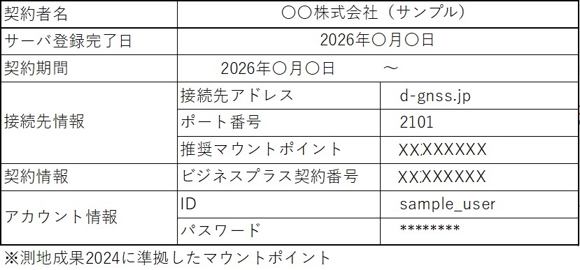
  1. After the service is activated, NTT DOCOMO Business will provide the information and documentation required to connect to the correction service. Follow the instructions provided to your organization and manage all contract-specific information and credentials securely.
tutorial How to validate RTK surveying accuracy in Japan
Account Information Email (Excerpt)
  1. When configuring the NTRIP client, enter the caster address, port number, mount point, user ID, and password specified by your correction service provider. 
Table 1. Connection Information Summary (Actual values depend on contract)
Item Example
Ntrip Caster (Server) D-gnss.jp
Port 2101
Mount Point* MOUNT_POINT_NAME
User ID** sample_user
Password** ********

* Select the appropriate mount point if multiple options are available.

** Use your user ID and password.

Connect SW Maps to the GNSS receiver

  1. Follow the User Guide to set up your RTK kit with SW Maps using the step-by-step instructions. Here, we provide a high-level overview of the process.
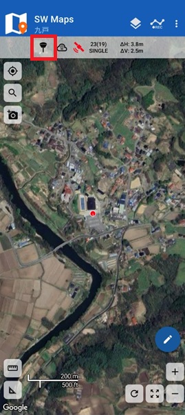
  1. Launch SW Maps and tap the External GNSS Receiver Settings icon.
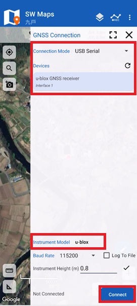
  1. Select items 1 through 4 on the screen according to your setup details, then tap Connect. (Note 5: If elevation precision is required, enter the antenna height.)
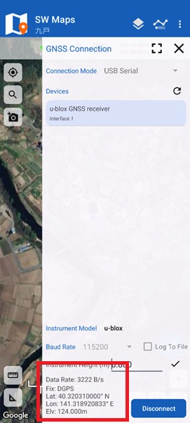
  1. Once successfully connected, position data reception will begin, and your current location will be displayed on the screen.

Enable NTRIP Client connection

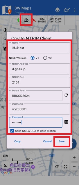
  1. Tap the NTRIP Connection Settings icon to open the configuration screen. Set and enter each field (1–8) as required, then tap Save. (Note 5: Display varies depending on the connection service; tap to select the appropriate mount point. For DOCOMO service details,  click here).
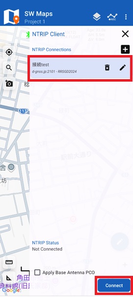
  1. Tap the NTRIP Connection Settings icon again to select your saved profile. Tap Connect; upon a successful connection, correction data streaming from the NTRIP server will begin.
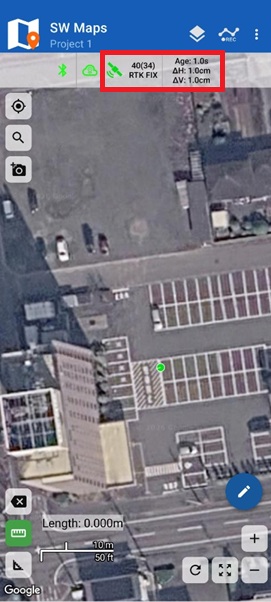
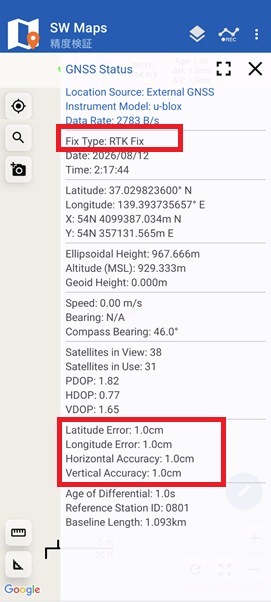
  1. A few seconds after receiving correction data, the status will switch to RTK FLOAT and then RTK FIX, enabling high-precision positioning.

Find public geodetic control points

To verify that the RTK-GNSS positioning is operating accurately, compare your measured values against public control points with known coordinates.
This section explains how to search for public control points using the GSI “Control Point Results Viewer” and compare field RTK measurement results with official records.

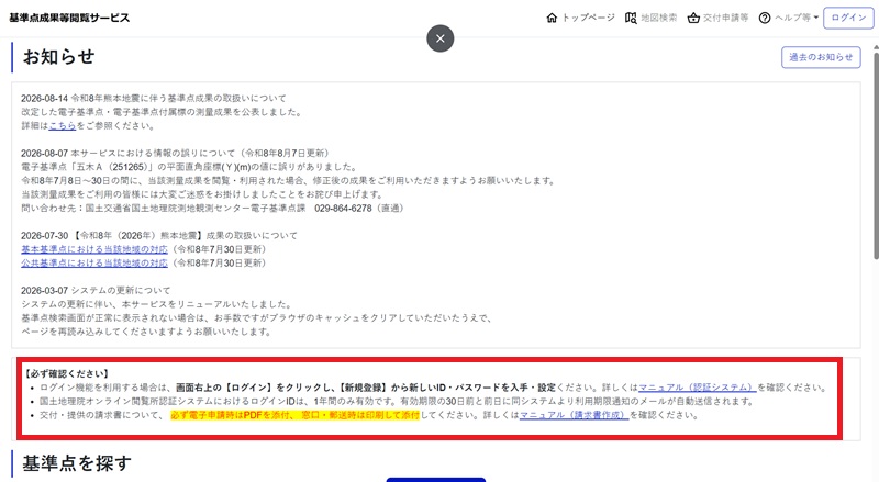
  1. Access the GSI Control Point Results Viewer”website and log in. If you are using the service for the first time, click “New Registration” to create an account and obtain your user ID and password.
tutorial How to validate RTK surveying accuracy in Japan
Example of the Control Point Results Viewer Interface
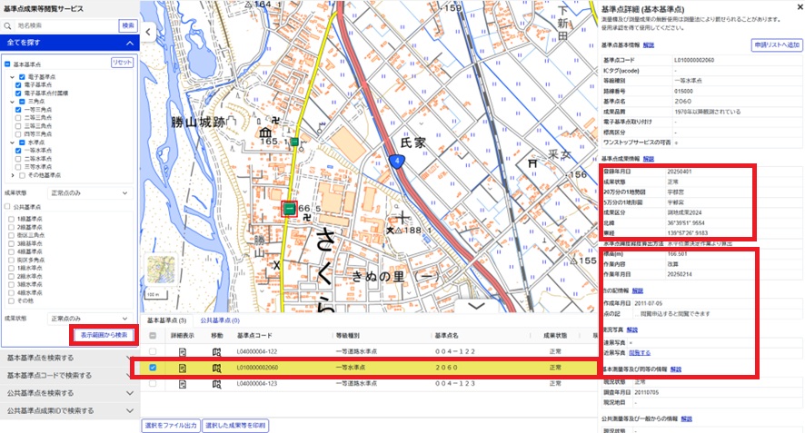
  1. Select a control point on the map to view its detailed information and published coordinates. Record the following details for comparison with field measurement results: • Control Point Name • Control Point Code • Latitude and Longitude • Elevation (Orthometric Height) or Ellipsoidal Height • Status and usability information Additionally, check location descriptions and point notes beforehand to help locate the physical control point on site.
tutorial How to validate RTK surveying accuracy in Japan
Example of Control Point Information Display

Verify accuracy on control point on site

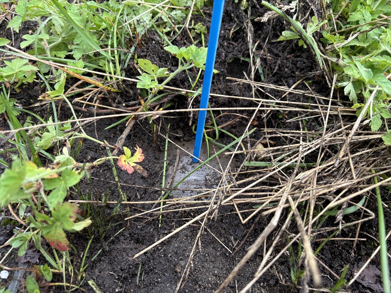
  1. Travel to the public control point location and locate the physical mark. Check for obstructions such as buildings, trees, or utility poles that could block GNSS satellite signals. Clear sky visibility is critical; obstructed views can reduce positioning accuracy. Before starting measurement, verify that the point name and physical location match your recorded reference data.
tutorial How to validate RTK surveying accuracy in Japan
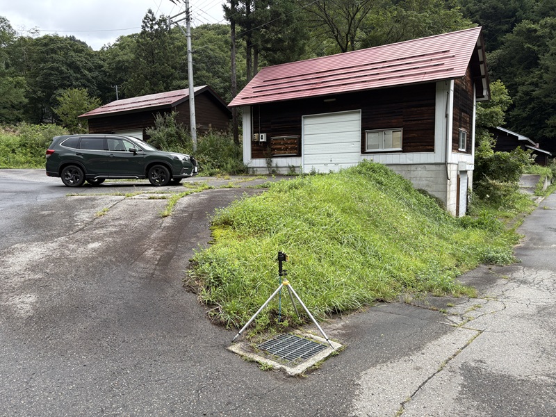
Overview of Verification Site
  1. Make sure that your GNSS receiver is connected to SW Maps and initiate NTRIP correction data streaming. Confirm that the status changes to RTK FIX.
  1. Align the center of the GNSS antenna directly above the mark center.
manual How to validate RTK surveying accuracy in Japan
Overview of Verification Site
  1. Measure the height from the mark to the GNSS antenna reference point using a measuring tape, and enter the precise antenna height into SW Maps.
  2. Wait for the reading to stabilize, then record the measured latitude, longitude, and height.

Compare survey results

  1. Compare the RTK-GNSS survey results against official coordinates from the GSI service.
    • Horizontal Position: Compare the measured latitude/longitude or converted Plane Rectangular Coordinates with the official control point coordinates. Converting the coordinate differences into meters or centimeters makes the accuracy easier to evaluate.
    • Height: Pay close attention to the difference between Elevation (Orthometric Height) and Ellipsoidal Height. Comparing these two height types directly will result in an incorrect accuracy assessment.Compare the RTK-GNSS survey results with the official coordinates provided by the GSI service.
  1. To calculate Elevation from Ellipsoidal Height, use the following formula:
    Elevation = Measured Ellipsoidal Height − Geoid Height
    This relationship is also defined by the GSI in its explanation of “What is a Geoid?”. When using SW Maps, height values depend on the GNSS receiver output settings and the geoid settings configured in the app. Before comparing results, verify whether the reported value is Ellipsoidal Height or Elevation (Mean Sea Level). Make sure that the geoid correction has not been applied twice. Also, verify that the antenna height offset has been configured correctly and is not being counted twice.
  1. The results confirm that the low-cost RTK Handheld 2 kit can achieve centimeter-level positioning accuracy for static measurements when using RTK corrections and is compatible with Japanese correction services.
No Verification site #1 Control Point Coordinates ArduSimple Handheld 2 Survey Results Error / Discrepancy
X (m) Y (m) Z (m) X (m) Y (m) Z (m) ΔX (m) ΔY (m) Horiz. Offset (m) Elev. Offset (m)
1 Measurement 1 114,356.997 -39,110.223 923.087 114,357.001 -39,110.230 923.046 -0.004 0.007 0.008 0.042
2 Measurement 2 114,356.997 -39,110.223 923.087 114,357.001 -39,110.233 923.041 -0.004 0.010 0.011 0.047
3 Measurement 3 114,356.997 -39,110.223 923.087 114,356.997 -39,110.232 923.041 0.000 0.009 0.009 0.047

Troubleshooting discrepancies

If a large discrepancy occurs between measured values and official records, verify the following:

  • Is the positioning status fixed at RTK Fix?
  • Is NTRIP correction data being received normally?
  • Are the control point ID and official coordinate values correct?
  • Do the geodetic datum and release epoch match between the survey data and official results?
  • Are you comparing matching height categories (Ellipsoidal vs. Elevation)?
  • Is the antenna height correctly set in the software?
  • Is the GNSS antenna precisely centered over the benchmark point?
  • Is the antenna or pole perfectly vertical without tilting during measurement?
  • Is the distance between the measurement point and the NTRIP base station excessive?
  • Are there physical obstructions or multipath sources nearby (e.g., buildings, fences, utility poles)?

If you want to follow this tutorial we have all the products in stock and ready to be shipped worldwide within 1-3 days.

RTK Assistant

Find the best products for your application in just a few questions.

If you liked this content, you can follow us on Twitter, YouTube, Facebook or LinkedIn to stay updated of content like this.

Got any questions or requests?
Contact us! We'll answer <24 hours!

Contact ArduSimple
Close

Access your Account and orders

Or

New customer? Create your account
ArduSimple – high precision RTK survey equipment and solutions made simple

Want to learn more about GPS and RTK?

If you are busy right now, our engineers can send you 3 short e-mails, explaining all you need to know to start your project.