Update (15/06/2026): We have plenty of stock of all our products, find us also in and    How to get a quotation

Field test evaluation of simpleRTK2B Lite ZED-F9P on the South Carolina Virtual Reference Network

Field testing of u-blox zed-f9p simpleRTK2B Lite on the South Carolina Virtual Reference Network cover

Table of contents

Introduction

In 2020, Professor Michael E. Hodgson, from the Department of Geography, University of South Carolina, Columbia, SC, USA completed a rigorous field test evaluation of the RTK Portable Bluetooth Kit operating in RTK mode on the South Carolina Virtual Reference Network (SCRTN).

Professor Hodgson was in the process of retiring his Topcon GRS-1 receiver/antenna and was looking for a suitable multi-constellation and L1/L2 replacement. The review was conducted for his university research use to support with evaluation of LiDAR data and aerial image georectification/model building from drone imagery.

Methodology

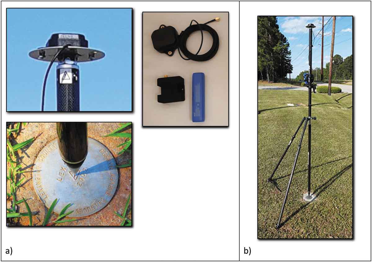
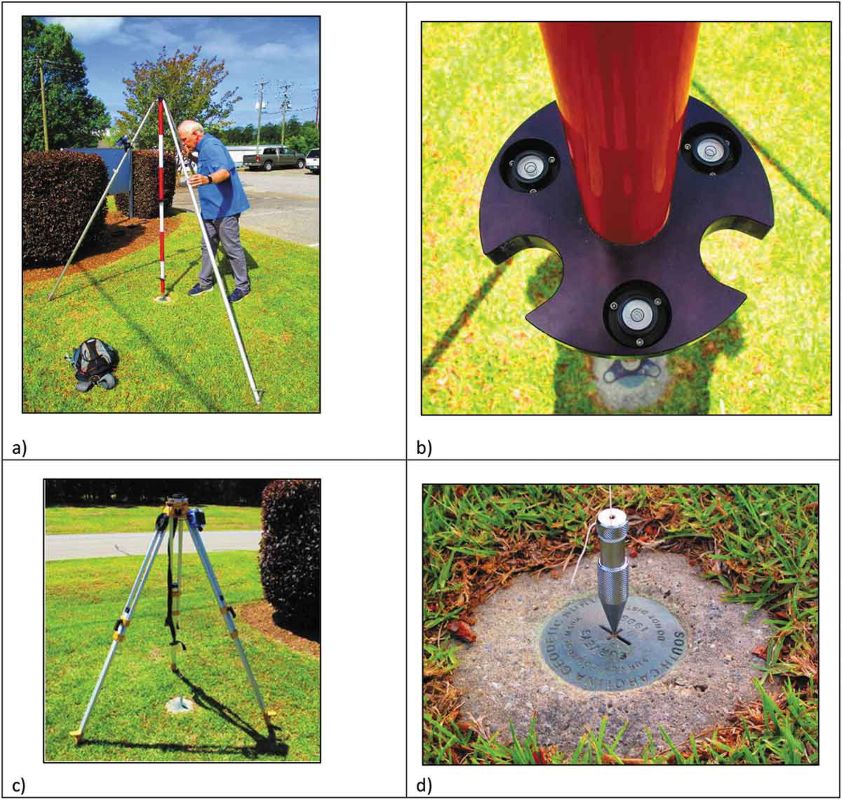
The ANN-MB antenna was mounted on the steel plate with 5/8″ nut for mounting on a 2-meter fixed height pole.

Field testing of u-blox zed-f9p simpleRTK2B Lite on the South Carolina Virtual Reference Network setup base
GNSS survey grade receiver (Ardusimple SimpleRTK2B Lite) used for the empirical assessment and antenna (U-blox ANN-MB) mounted to ground plane with 5/8” nut on back for attachment to fixed height rover pole (a). The bipod and fixed height 2-m rover setup in b) is the same used for all 36 monuments. Source: Hodgson, M. E. (2020). On the accuracy of low-cost dual-frequency GNSS network receivers and reference data. GIScience & Remote Sensing, 57(7), 907–923.

Field test results

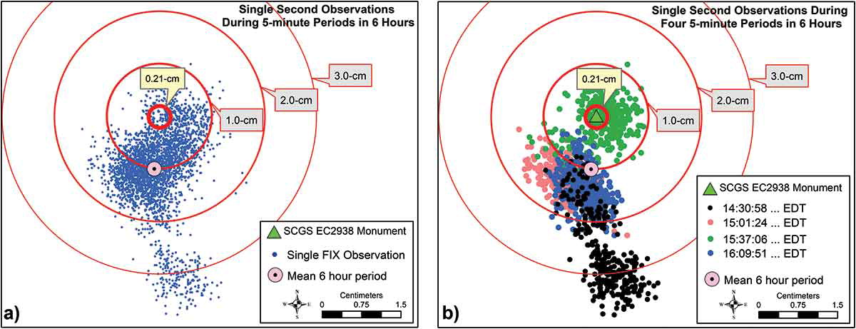
A longer occupation test was conducted with the antenna plumbed over a survey monument to examine the performance over short and longer averaging times and to look at the dispersion of subsequent one-second observations in a temporal period. The baseline was 96-meters. The observed accuracies (RMSE) for the horizontal and vertical dimensions were 1.3-cm and 1.8-cm, respectively.

Field testing of u-blox zed-f9p simpleRTK2B Lite on the South Carolina Virtual Reference Network setup plumbed
State geodetic survey director leveling fixed height survey pole with GNSS receiver antenna at monument EC2938 (a), three bubble levels on fixed tripod (b), lower tripod mount (c), and use of plumbed tripod for antenna (d). Source: Hodgson, M. E. (2020). On the accuracy of low-cost dual-frequency GNSS network receivers and reference data. GIScience & Remote Sensing, 57(7), 907–923.

He subsequently tested the accuracy (horizontal and vertical) in the Piedmont Central South Carolina surroundings and the mountainous environment in northern South Carolina at different National Geodetic Survey monuments. The context of the tests were to evaluate the performance as a research scientist or surveyor would use the unit attached to an RTK network. For the piedmont environment the evaluation used 36 NGS monuments. The horizontal and vertical accuracies (RMSE) observed were 2.18-cm and 2.20-cm, respectively.

Field testing of u-blox zed-f9p simpleRTK2B Lite on the South Carolina Virtual Reference Network final accuracy
All observations (3700) in the 5-minute occupation periods during the 6-hour test (a). Four sequential 5-minute periods separated by 30-minutes in (b). Each second a new, non-averaged, FIX position was recorded. The reported SCGS monument where antenna was plumbed is shown as a green triangle with an expected accuracy of 0.21-cm (95% confidence level). Source: Hodgson, M. E. (2020). On the accuracy of low-cost dual-frequency GNSS network receivers and reference data. GIScience & Remote Sensing, 57(7), 907–923.

Taylor & Francis have published the GIScience and Remote Sensing journal article.

Related products

Would you like to build your own kit for precise ground settlement measurements?  Our products provide the reliability and accuracy you need.

If you liked this content, you can follow us on Twitter, YouTube, Facebook or LinkedIn to stay updated of content like this.

Got any questions or requests?
Contact us! We'll answer <24 hours!

Icon
Contact ArduSimple
Close
ArduSimple – high precision RTK survey equipment and solutions made simple

Want to learn more about GPS and RTK?

If you are busy right now, our engineers can send you 3 short e-mails, explaining all you need to know to start your project.