How to connect ArduSimple kit to OCAD for your mapping projects

OCAD is a Windows software that enables you to create and edit a variety of maps, including topographic, orienteering maps, on your PC or tablet. Complementing the desktop version, the OCAD Sketch App is perfect for field mapping using smartphone—ideal for creating new maps or updating existing ones based on course planner or reviewer feedback.
If your Windows or Android device has a standard internal GPS that provides only 5-10 meter accuracy, consider connecting an external GNSS/RTK receiver. This will enhance your position accuracy in OCAD to the centimeter level. This tutorial will show you how to connect the ArduSimple RTK kit to OCAD for precise map designs.
Before starting the tutorial, you need to find a NTRIP service provider that operates within your area. If you are not aware of them, check this list. Most of these services are free but require registration.
Required hardware:
- RTK Calibrated Surveyor Kit
- A Windows PC or laptop with internet connection
- An Android smart phone or tablet with internet connection
Required software:
- OCAD (for Windows PC)
- OCAD Sketch App (for Android smart phone or tablet)
- U-center (download u-center for F9, not u-center2)
- Virtual Serial Port Tools
How to Use ArduSimple with OCAD for centimeter-level accurate map design?
Firstly, connect to NTRIP correction service via PC.
NTRIP (Networked Transport of RTCM via Internet Protocol) is a protocol for transmitting RTK correction data over the internet, often sourced from a network of base stations. By using an NTRIP service, you can achieve centimeter-level positioning accuracy without the need to set up your own base station.
Since OCAD lacks a built-in NTRIP correction feature, we will use u-center to connect to the NTRIP service. To enable this, a Serial Port Splitter is required to divide the receiver’s COM port: one connection for receiving corrections and another for linking to OCAD.
Since OCAD lacks a built-in NTRIP correction feature, we will use u-center to connect to the NTRIP service. To enable this, a Serial Port Splitter is required to divide the receiver’s COM port: one connection for receiving corrections and another for linking to OCAD.
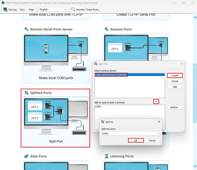
- Connect the receiver to your computer. Open Virtual Serial Port Tools (Or any other serial port splitter tool works on your PC or tablet). Go to Splitted Port. At existing device select your u-blox GNSS Receiver COM port, click Create. At Split to click + to add two new COM ports. Click OK.
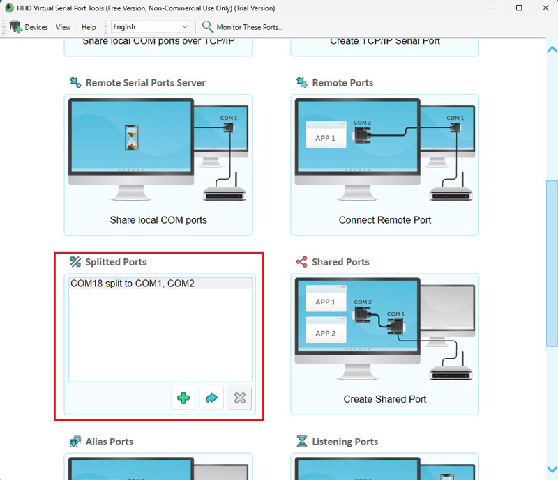
- You will see the u-blox COM port split to COM1 and COM2.
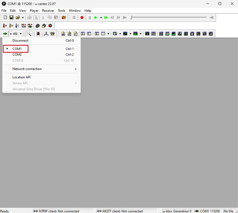
- Open u-center and connect your receiver to it via COM1. Connect to NTRIP correction. If you don’t know how to do it follow the tutorial How to connect simpleRTK2B series receiver to a NTRIP correction service via PC.
Secondly, connect your receiver to OCAD.
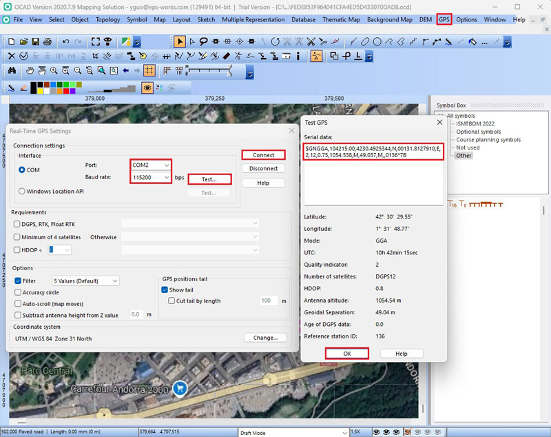
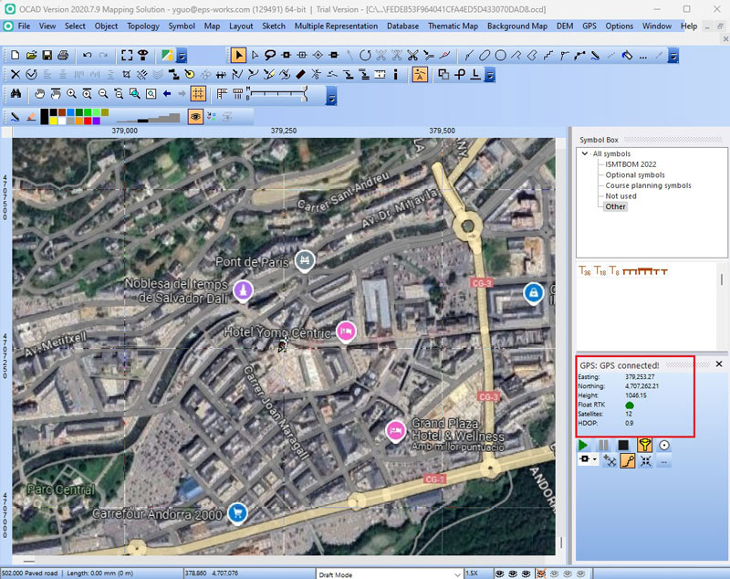
- Open OCAD. At menu bar go to GPS–>Real Time GPS. At Port choose COM2, Baud rate choose Click Test… you will see GGA data coming in. Click Ok and Connect.
- On the right side, you will see GPS connection status and your location information. You can use GPS to mark points or record tracks.
Finally, use OCAD Sketch on your Android devices.
- OCAD Sketch doesn’t have built in NTRIP function, but don’t worry, you can connect to GNSS Master for NTRIP correction and use Mock location on OCAD.
You can follow our tutorial How to use centimeter GPS with any Android app (mock location) to do this.
Now you can enjoy centimeter-accuracy for your mapping projects on both of your PC and mobile devices.
If you want to follow this tutorial, we have all the products in stock and ready to be shipped:
 and
and 

